Map Gallery
Published on
Image
Seismic surveys have been used extensively in Australia by Geoscience Australia to map undersea geology and by various companies exploring for oil and gas deposits, particularly on the NW shelf (for example, at Scott Reef in 2007).
Published on
Image
Surprisingly common across the world's oceans, bioluminescence (watch a video of how it works) occurs when a chemical reaction in living cells causes them to emit light - typically in shades of blue and green.
Published on
Image
The RV Southern Surveyor was a 66.1 m research vessel operated by the Australian Commonwealth Scientific and Industrial Research Organisation from 2003-2013 (take a virtual tour).
Published on
Image
The RV Southern Surveyor was a 66.1 m research vessel operated by the Australian Commonwealth Scientific and Industrial Research Organisation from 2003-2013 (take a virtual tour).
Published on
Image
The RV Southern Surveyor was a 66.1 m research vessel operated by the Australian Commonwealth Scientific and Industrial Research Organisation from 2003-2013 (take a virtual tour).
Published on
Image
The RV Southern Surveyor was a 66.1 m research vessel operated by the Australian Commonwealth Scientific and Industrial Research Organisation from 2003-2013 (take a virtual tour).
Published on
Image
The RV Southern Surveyor was a 66.1 m research vessel operated by the Australian Commonwealth Scientific and Industrial Research Organisation from 2003-2013 (take a virtual tour).
Published on
Image
The RV Southern Surveyor was a 66.1 m research vessel operated by the Australian Commonwealth Scientific and Industrial Research Organisation from 2003-2013 (take a virtual tour).
Published on
Image
The RV Southern Surveyor was a 66.1 m research vessel operated by the Australian Commonwealth Scientific and Industrial Research Organisation from 2003-2013 (take a virtual tour).
Published on
Image
The RV Solander is a 34.9 m long marine research vessel operated by the Australian Institute of Marine Science (take a virtual tour, map its current position).
Published on
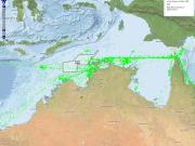
Image
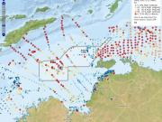
Australia is the fifth largest user of shipping in the world with more than 11,000 vessels from 600 overseas ports visiting Australia's 65 major ports each year.
Published on
Image
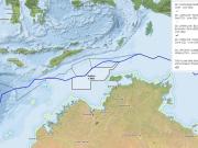
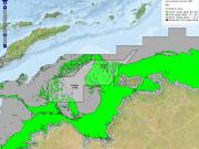
As an island continent, Australia has sovereign rights over a vast area of ocean, along with the fishery, mineral, and petroleum resources found in that area.
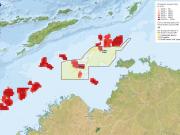
Published on
Image
The type, size and distribution of sediments on the seabed plays an important role in determining the suitability of a given area for settlement by benthos.
Published on
Image
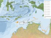
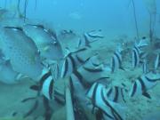
Dusky whaler sharks are widely distributed throughout the world's tropical and warm temperate waters (watch a video). This includes NW Australia's Oceanic Shoals CMR.
Use the interactive map below to explore the home range of these sharks within and beyond the CMR. How to use the map Click on this icon at the top left of the map to see a full screen version.
Click on this icon also at the top left of the map to zoom in closer to (+) or further from (-) the map.
Published on
Image
Australia is the fifth largest user of shipping in the world with more than 11,000 vessels from 600 overseas ports visiting Australia's 65 major ports each year.
Published on
Image
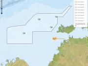
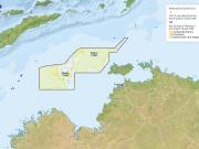
Submerged reefs and shoals are important features of the North West Marine Region of Australia due to their diverse and often unique benthic (e.g., corals, sponges) and fish biodiversity.
Published on
Image
Submerged reefs and shoals are important features of the North West Marine Region of Australia due to their diverse and often unique benthic (e.g., corals, sponges) and fish biodiversity.
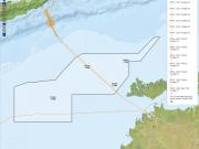
Published on
Image
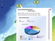
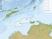
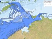
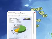
Find out what scientists have learned about Glomar Shoal and Rankin Bank via field surveys by clicking on the interactive map to see maps, videos and reports.
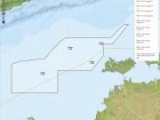
Published on
Image
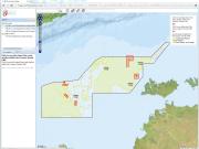
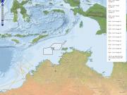
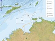
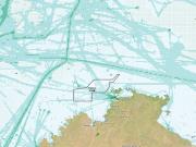
Find out where scientists have surveyed the Oceanic Shoals Australia Marine Park in detail, and what they have learned.
Published on
Image
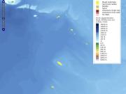
This map shows the abundance of Red Emperor fish found in neighbouring Blue (fished) and Green (non-fished) reefs. These measurements were taken using Baited Underwater Video System cameras.