Articles

Published on
IMG_3968.JPG
The Land and Sea Management Strategy for Torres Strait (2016-2036) (‘the Strategy’) is a guiding framework for enabling Torres Strait Islander and Aboriginal people to continue to sustainably manage and benefit from their land, sea and cultural resources into the future.
Published on
Acropora millepora

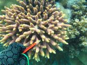
In 2013 and 2014 AIMS undertook a biodiversity survey of coral and fish species on the reefs around 5 islands in Torres Strait. This article shows the coral photo collection that was taken for species identification.

Published on
Woiz Reef - Torres Strait Temperature Logger (Flat Logger: WOIZFL1)
As part of the NERP TE project 2.3 temperature loggers were deployed at 15 sites across the Torres Strait to measure ocean temperature.
Published on
Torres Strait Islands Reefs Poster 2014
This poster map shows satellite and aerial imagery of Torres Strait. It also shows the Australia Maritime Boundariers in the region. This region neighbours with Papau New Guinea resulting in complex maritime boundaries.
Published on
Windsofzenadth
The Winds of Zenadth Cultural Festival takes place every two years on Thursday Island.
Published on
Paul Muir coral identification Nerp 2.3

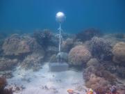
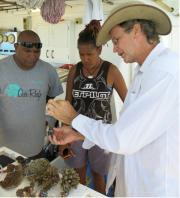
During trips to Torres Strait in collaboration with TSRA in 2013 and 2014 coral skeletons were collected under a permit issued by the Commonwealth of Australia under the Torres Strait Fisheries Act 1998.

Published on
Seagrass
Seagrass meadows in Torres Strait are abundant and widespread. Seagrass/algal beds have been rated as the third most valuable ecosystem globally for ecosystem services. Their value is due to their diverse roles within marine coastal ecosystems. Like other plants seagrass harvest the sun’s energy and thus are a source of primary productivity; energy that can be passed through the marine food chain. Seagrass is a major food source for dugong, a marine mammal of high importance culturally and as food throughout the region.
Published on
Close up of bulk carrier ship from Torres Strait
A plethora of recreational and commercial vessels operate within or transit Torres Strait. They unite the island communities and are a key transport mechanism for all kinds of goods and services. While shipping offers many benefits to the Torres Strait there are also associated risks, especially in event of an accident. These include threats to water quality, biodiversity and ecosystem health, physical or chemical damage from groundings and the introduction of pests.
Published on
Dugong
Dugong (Dugong dugon) are air-breathing marine mammals of global conservation significance, that can grow up to three metres, weigh up to 400kg and live for at least 70 years. Females reach sexual maturity at six years, and produce a calf only once every 2.5-5 years thereafter. Gestation period is 14 months, but calves suckle milk from their mothers for 18 months after birth. Dugongs’ main food source is seagrass, but they also eat invertebrates such as worms, sea squirts, and shellfish.
Published on
Flood Plume from Fly River (Landsat 5)

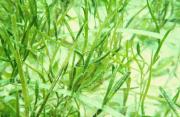
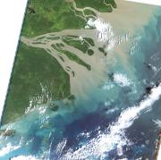
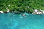
The Torres Strait marine environment contains a relatively shallow (<20m) and highly productive stretch of seawater between the tip of Queensland and Papua New Guinea. It straddles the juncture of the Indian Ocean (Arafura sea) with the Pacific Ocean (Coral Sea), resulting in complex patterns of influence from the two ocean systems, including complicated tides and currents, and high biodiversity. Torres Strait contains over 100 islands, and a diversity of marine habitats including coral reefs, seagrass meadows, and rich benthic garden communities.

Published on
Torres Strait map
As part of Project 2.3 broadscale surveys and biodiversity assessments were conducted in the central island group and eastern island group within the Torres Strait region. Broadscale surveys were conducted by manta tow in February 2013 at Aureed Island Reef, Aukane Island Reef, Kabbikane Island Reef, Masig Island Reef, Mer Island Reef and Waier and Dauar Island Reef.
Published on
csiro-ts-catalogue-preview.jpg

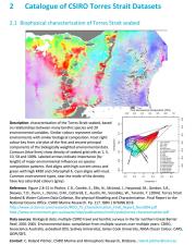
This milestone report presents a catalogue of information for the most significant and updated data sets, metadata and map compositions for the Torres Strait region, which may be suitable for inclusion in the Torres Strait eAtlas.

Published on
Tidal inundation on Thursday Island, Torres Strait

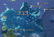
This report provides a synthesis of research on climate change and coastal science in the Torres Strait, and has been produced for the Australian Government’s Marine and Tropical Sciences Research Facility (MTSRF). It identifies and summarises work to date on reef evolution, hydrodynamics and sedimentary environments throughout the Torres Strait. It describes the island dynamics at Boigu, Saibai, Masig, Poruma, Warraber and Iama Islands.

Published on
Torres Strait

Researchers funded through the Australian Government’s Marine and Tropical Sciences Research Facility (MTSRF) have worked closely with Torres Strait communities to improve our understanding of both the vulnerability of Torres Strait islands to climate change, and their adaptation capacity.

Published on
Torres Strait Baseline Conference Proceedings

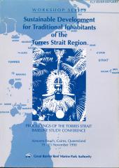
Proceedings of the Torres Strait Baseline Study Conference edited by David Lawrence and Tim Cansfield-Smith

As part of Torres Strait Baseline study a conference was run on the physical, biological and human environments of the Torres Strait region. The full proceedings of this conference are from the GBRMPA Workshop Series 16.

Published on
Torres Strait Baseline Conference Proceedings
In July 1989 the Australian Government funded a four year environmental study of the Torres Strait marine environment.