North West Atlas home page

Image
North West Atlas header (950x398)

Recent articles and projects

Published on
Montage
We used data from satellite telemetry tags attached to six species of threatened and migratory marine megafauna across three taxonomic groups (marine turtles, whales and sharks) off the coast of north-western Australia to map their areas of use. We then compiled spatial data from a range of threats and overlayed species and threat maps to assess the level of exposure of the species to threats.
Published on
Oyster on Albert reef
We use genetics to estimate how far and wide oyster larvae can disperse to assist in setting biologically relevant spatial boundaries and harvest limits for oysters.
Published on
Pygmy blue whale
To assist in recovery of the population, spatial areas of importance to pygmy blue whales, known as Biologically Important Areas (BIA), have been identified by the Australian Government. The AIMS team and collaborators Centre for Whale Research and Curtin University set out to reduce uncertainty in identifying where important foraging areas for this species and their migration pathways and distribution exist, and the extent to which they overlap with anthropogenic activities by deploying satellite tags.
Published on
NWS2S benthic habitat still Area 1 Tow 3 Photo 3
Key Ecological Features (KEFs) are parts of the marine ecosystem considered to be of particular importance for either a region's biodiversity or its ecosystem function and integrity. 13 KEFs have been defined for Australia’s North-west Marine Region, including the ‘Ancient Coastline at 125m depth contour’ (AC125). The AC125 is thought to “provide areas of hard substrate and therefore may provide sites for higher diversity and enhanced species richness relative to surrounding areas of predominantly soft sediment.” Little is known about what habitats exist on the sea floor in the AC125.
Published on
Arafura Money Shoal Reefscenery CAM 54
The information in this eco-narrative forms an initial characterisation of the physical, oceanographic and biological character of Arafura Marine Park, with a focus on results from a biodiversity and mapping survey undertaken by the NESP Marine Biodiversity Hub in 2020. This survey targeted two areas (see map below): Money Shoal as an example of shallow coral reef habitat, and Pillar Bank as an example of a deeper water mixed seabed environments. This excerpt focuses mainly on Money Shoal.

Recent datasets

BRUVS surveys collected for the Barossa Environmental Baseline Study 2015, Western Australia (ConocoPhillips)

Published on
27 June 2017

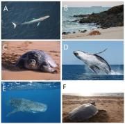
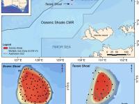
Stereo Baited Remote Underwater Video Stations (BRUVS) were deployed and retrieved across two shoals of regional interest, Evans and Tassie Shoals, two of the closest shoals to the Barossa field. The allocation of deployment positions across each shoal was conducted using a regular/random design within the bounds of the 60 m depth contour whilst maintaining a minimum distance of 250 m between each stereo-BRUVS unit. Once the positions were derived, the sequence of deployments, in sets of eight replicate units, was determined by proximity and prevailing sea conditions on the day.

BRUVS deployments to address strategic knowledge gaps in the Oceanic Shoals bioregion 2014, Western Australia (AIMS)

Published on
27 June 2017

Stereo Baited Remote Underwater Video Stations (BRUVS) were deployed and retrieved across targeted shallow seabed environments within and adjacent to the proposed Oceanic Shoals Commonwealth Marine Reserve (CMR) in the Timor Sea. The survey concentrated on shelf habitats (< 200m) of the Oceanic Shoals CMR and included potential biodiversity hotspots such as pinnacles, banks and shoals.

Towed Video deployments for the Barossa Environmental Baseline Study 2015, Western Australia (ConocoPhillips)

Published on
27 June 2017

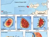
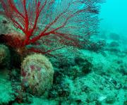
Towed video surveys were carried out across five principle locations of regional interest, including Evans, Tassie and Blackwood Shoals, the closest shoals to the Barossa field, as well as two mid-shelf seabed locations adjacent to Goodrich Bank and Cape Helvetius. In total, 113 towed video transects and 2246 downward facing digital still images were collected at depths of between 11 and 100 metres.

BRUVS deployments in Oceanic Shoals Commonwealth Marine Reserve (Timor Sea), Western Australia (NERP)

Published on
02 June 2017

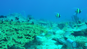
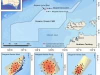
Stereo-Baited Remote Underwater Video Stations (BRUVS) were deployed and retrieved in targeted shallow seabed environments within the proposed Oceanic Shoals Commonwealth Marine Reserve (CMR) in the Timor Sea. The survey concentrated on shelf habitats (< 200m) of the western part of the Oceanic Shoals CMR and included potential biodiversity hotspots such as pinnacles, banks and shoals. In total, 56 stereo-BRUVS were deployed between 31 and 77 metres for one hour according to a regular random sampling design, with minimum spacing of 400 m to ensure independence among samples.

Towed Video deployments in Oceanic Shoals Commonwealth Marine Reserve (Timor Sea), Western Australia (NERP)

Published on
25 May 2017

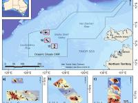
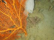
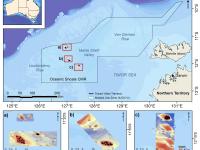
Towed video surveys were carried out in targeted shallow seabed environments within the proposed Oceanic Shoals Commonwealth Marine Reserve (CMR) in the Timor Sea. The survey concentrated on shelf habitats (< 200m) of the western part of the Oceanic Shoals CMR and included potential biodiversity hotspots such as pinnacles, banks and shoals. In total, 52 towed video transects were collected at depths of between 31 and 129 metres.