Articles

Published on
Montage
We used data from satellite telemetry tags attached to six species of threatened and migratory marine megafauna across three taxonomic groups (marine turtles, whales and sharks) off the coast of north-western Australia to map their areas of use. We then compiled spatial data from a range of threats and overlayed species and threat maps to assess the level of exposure of the species to threats.
Published on
Oyster on Albert reef
We use genetics to estimate how far and wide oyster larvae can disperse to assist in setting biologically relevant spatial boundaries and harvest limits for oysters.
Published on
Pygmy blue whale
To assist in recovery of the population, spatial areas of importance to pygmy blue whales, known as Biologically Important Areas (BIA), have been identified by the Australian Government. The AIMS team and collaborators Centre for Whale Research and Curtin University set out to reduce uncertainty in identifying where important foraging areas for this species and their migration pathways and distribution exist, and the extent to which they overlap with anthropogenic activities by deploying satellite tags.
Published on
NWS2S benthic habitat still Area 1 Tow 3 Photo 3
Key Ecological Features (KEFs) are parts of the marine ecosystem considered to be of particular importance for either a region's biodiversity or its ecosystem function and integrity. 13 KEFs have been defined for Australia’s North-west Marine Region, including the ‘Ancient Coastline at 125m depth contour’ (AC125). The AC125 is thought to “provide areas of hard substrate and therefore may provide sites for higher diversity and enhanced species richness relative to surrounding areas of predominantly soft sediment.” Little is known about what habitats exist on the sea floor in the AC125.
Published on
Arafura Money Shoal Reefscenery CAM 54
The information in this eco-narrative forms an initial characterisation of the physical, oceanographic and biological character of Arafura Marine Park, with a focus on results from a biodiversity and mapping survey undertaken by the NESP Marine Biodiversity Hub in 2020. This survey targeted two areas (see map below): Money Shoal as an example of shallow coral reef habitat, and Pillar Bank as an example of a deeper water mixed seabed environments. This excerpt focuses mainly on Money Shoal.
Published on
hawksbill_green_montage revised-700x652.jpg
Global populations of green (IUCN listing endangered) and hawksbill (IUCN listing critically endangered) turtles are declining due to a range of threats. Australia supports some of the largest rookeries (nesting sites) for these turtles in the Indo-Pacific. Even though they've been much studied, most data that shows where these turtles spend their time around Australia remains unpublished. Here, we set out to quantify and map the important areas that turtles use to help refine these protected areas and assist with turtle conservation management.
Published on
Oyster on Albert reef
The Silver Lipped Oyster, Pinctada maxima, forms the basis of a historical fishery in tropical Western Australia, estimated to be worth $A61 million in 2013. This fishery supplies pearl and mother of pearl markets through wild harvest of P. maxima stock, augmented more recently with aquaculture. Studies have shown that populations of P. maxima within the region are highly connected to one another. This raises the question of whether oysters located deeper than those safely visited by divers (beyond 30-40 metres) may help replenish stocks in shallower areas. At present, the extent to which P.
Published on
KEFArea5_25_snappers_cods_emporers.jpg
The North West Shoals to Shore Research Program investigated seabed habitats and their biodiversity to inform management and sustainable development of the region. Little is known about the fish found on and around the AC125. Part of the reason is that the AC125 is very deep, and thus difficult to observe. One question to ask about a habitat is how many different species of fish are found there - this is called fish species 'richness'. We explored this question for 5 study areas spread along the vast AC125 (see map below, read the full paper here).
Published on
KEFArea5_1_banner.jpg
Little is known about what fish species call the AC125 home. Part of the reason is that the AC125 is very deep, and thus difficult to observe. To fill this gap, we conducted fish relative abundance and diversity surveys across five study Areas of the AC125 using Baited Remote Underwater Video Stations (BRUVS). BRUVS were deployed on and off the AC125 at a minimum distance of 500 m between each unit. A total of 204 BRUVS deployments were conducted at depths between 62.1 m and 181.4 m across each study Area from the RV Solander.
Published on
in-the-field.jpg

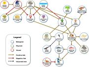
Understanding the management and governance of Australia’s vast coastline can be complex.

Published on
Indigenous research collaborations

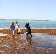
Bardi-Jawi Marine Rangers partner with marine scientists to research fish and coral recruitment processes in the Kimberley.

Published on
Crab in a sponge

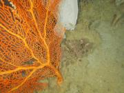
Sponge taxonomy is difficult and challenging, it requires adequate laboratory facilities, experience and time, which are often not available.

Published on
indigenous_protected_areas_2014.JPG
Indigenous Protected Areas (IPAs) in Australia are voluntarily dedicated by Indigenous groups on Indigenous owned or managed land or sea country.
Published on
glomar_KEF_qualitative_model.jpg
Learn more about the Glomar Shoals KEF, based on new knowledge of its benthic and pelagic environments that researchers within the NESP Marine Biodiversity Hub used to develop a preliminary model of the KEF's ecosystem components and processes.
Published on
article_preview_image.JPG
Explore how Barracouta East, Goeree and Vulcan shoals have changed over time.
Published on
mean primary productivity hotspots
Much of life on earth ultimately depends on the capture of light from the sun and its translation into energy via photosynthesis.
Published on
sst_summer_mean_screen_capture.JPG
Understanding sea surface temperature and how it varies across the globe over time is incredibly important.
Published on
icons_montage.jpg

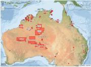
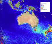
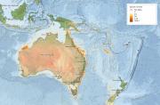
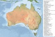
Biologically Important Areas (BIAs) are regions where aggregations of individuals of a particular species are known or likely to display important behaviors such as breeding, foraging, nesting or migration. They have been identified from the literature and using expert scientific knowledge about species' distribution, abundance and behavior. BIAs were created to inform decision-making under the EPBC Act, and have been defined for a selection of protected species only.

Published on
speciesRichness_PreviewImage_nwatlas.jpg
Species richness is a count of the number of different species that exist in a given region or ecological community.
Published on
ramsar_PreviewImage_nwatlas.jpg
Wetlands are a critical part of our natural environment.