Map Gallery
Published on
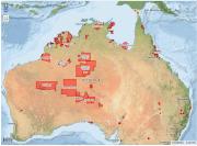
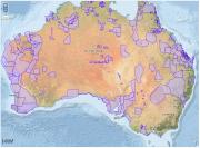
Indigenous Protected Areas (IPAs) in Australia are voluntarily dedicated by Indigenous groups on Indigenous owned or managed land or sea country.
Published on
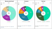
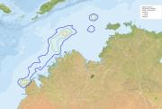
Explore how Barracouta East, Goeree and Vulcan shoals have changed over time.
Published on
Much of life on earth ultimately depends on the capture of light from the sun and its translation into energy via photosynthesis.
Published on
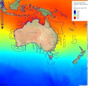
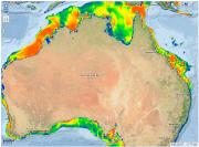
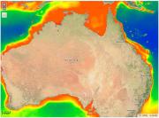
Understanding sea surface temperature and how it varies across the globe over time is incredibly important.
Published on
Flatback turtles (Natador depressus) are endemic to northern Australia, where they nest and forage in the region's sub-tropical and tropical waters.
Published on
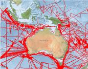
Australia’s marine industries are worth more than $50 billion a year.
Published on
Bottom current velocity can affect abundance and biodiversity of benthic fauna by altering disturbance regimes, changing available habitats, and regulating nutrient flows.
Published on
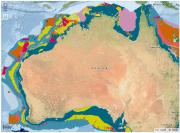
Geomorphologic features are categorical descriptors of the shape of the seabed that range in scale from thousands of km2 (e.g.
Published on
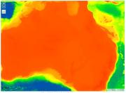
Chlorophyll-a can be estimated at continuous broad scales in the top layers of the ocean via satellite imagery (note this is different from chlorophyll-a in sediments).
Published on
Sediment grain-size is often assumed to be a key driver of infaunal communities (McArthur et al.
Published on
Depth is a consistently powerful explanatory variable in benthic studies (Gray 2001) due to its association with a range of other factors directly affecting abundance, biomass, and biodiversity (e.g.
Published on
Environment Australia is tasked with managing the networks of Commonwealth Marine Reserves (CMRs).
Published on
Native title is the recognition in Australian law that some Indigenous people continue to hold rights to their land and waters, which come from their traditional laws and customs.
Published on
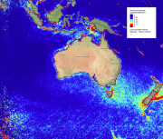
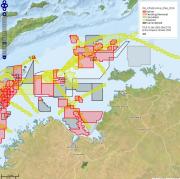
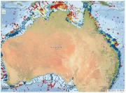
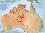
The map below shows the location of all multibeam bathymetry (shaded red) currently held by Geoscience Australia (GA) as of 2016 (see the metadata record).
Published on
The Australian Government developed its Indigenous Programs & Policy Locations (AGIL) dataset as an authoritative source of indigenous location names across Australia.
Published on
The National Native Title Tribunal was established by the Native Title Act 1993 to make decisions, conduct inquiries, reviews and mediations, and assist various parties with native title applications, and Indigenous land use agreements (‘ILUAs’).
Published on
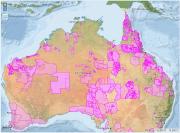
An Indigenous Land Use Agreement (ILUA) is an agreement about the use and management of land and waters made between people who hold, or may hold, native title in the area, and other people, organisations or governments.
Published on
Researchers from Project D1 of the Marine Biodiversity Hub of the National Environmental Science Programme present this interactive map-based summary of where pelagic fish are known to exist in the Key Ecological Features of the N and NW regions.
Published on
Researchers from Project D1 of the Marine Biodiversity Hub of the National Environmental Science Programme present this interactive map-based summary of where pelagic sharks and rays are known to exist in the Key Ecological Features of the N and NW regions.
Published on
Researchers from Project D1 of the Marine Biodiversity Hub of the National Environmental Science Programme present this interactive map-based summary of where demersal sharks & rays are known to exist in the Key Ecological Features of the N and NW regions.