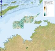
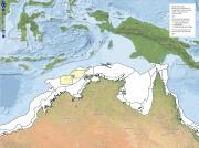
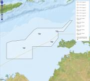
The Oceanic Shoals Commonwealth Marine Reserve is located offshore from NW Australia (see map) in Australia's northern network of marine protected areas. A management plan for this area is currently under development. This area is vast (~71,745 square km). View the interactive maps below to learn more about this region.
Oceanic Shoals Commonwealth Marine Reserve
Published on
Environment Australia is tasked with managing the networks of Commonwealth Marine Reserves (CMRs).
Published on
Australia’s marine industries are worth more than $50 billion a year.
Published on
Environment Australia is tasked with managing the networks of Commonwealth Marine Reserves (CMRs).
Published on
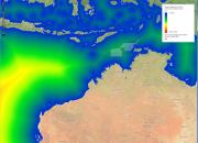
Water flowing along the sediments (mud, sand, gravel, rocks) that make up the ocean floor can move them (sediment transport) given sufficient energy (shear stress).
Published on
The topography of the seafloor can play a major role in determining what types and abundance of organisms can survive there as it controls water circulation (read how it works).
Published on
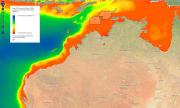
Turbidity is a measure of the cloudiness of water caused by suspended particles (so small that they are usually invisible to the naked eye) that limit the transmission of light through the water.
Published on
Much of life on earth ultimately depends on the capture of energy from the sun and its translation into energy via photosynthesis.
Published on
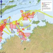
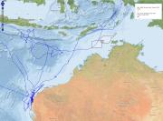
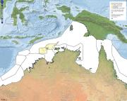
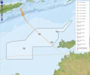
Use the interactive map below to see the relative distance of the Oceanic Shoals CMR from shore compared to other CMRs. Click on the four-arrow icon to activate the interactive map. You then click on the 'Commonwealth Marine Reserve boundaries' data layer to see how the Oceanic Shoals compares to the other CMRs. How to use the map Click on this icon at the top left of the map to see a full screen version.
Click on this icon also at the top left of the map to zoom in closer to (+) or further from (-) the map.
Published on
The Whale Shark is listed as vulnerable and migratory under Australia's Environment Protection and Biodiversity Conservation Act 1999 Act.
Published on
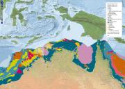
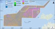
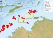
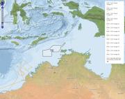
Geomorphology is a major driver of the type and abundance of organisms living on and near the sea floor. Much work has been done to define and characterise ocean geomorphology at spatial scales ranging from the entire world's oceans to the NW Australian region.
Use the interactive map below to see what geomorphological features occur within and beyond the Oceanic Shoals CMR. How to use the map Click on this icon at the top left of the map to see a full screen version.
Click on this icon also at the top left of the map to zoom in closer to (+) or further from (-) the map.
Published on
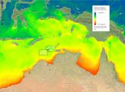
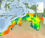
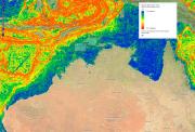
Sea surface temperature is the measure of how hot or corld the water in the ocean is at a given time and place.
Published on
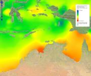
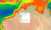
Salinity is the measure of how much salt is in the ocean at a given time and place (why is the ocean salty?).
Published on
The Integrated Marine and Coastal Regionalisation of Australia (IMCRA v4.0) classified Australia's marine environment into ecologically relevant bioregions for regional planning.
Published on
Coral reefs support a diverse array of life, including hard and soft corals, sponges, macroalgae and fish.
Published on
Seismic surveys have been used extensively in Australia by Geoscience Australia to map undersea geology and by various companies exploring for oil and gas deposits, particularly on the NW shelf (for example, at Scott Reef in 2007).
Published on
Surprisingly common across the world's oceans, bioluminescence (watch a video of how it works) occurs when a chemical reaction in living cells causes them to emit light - typically in shades of blue and green.
Published on
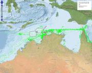
The RV Southern Surveyor was a 66.1 m research vessel operated by the Australian Commonwealth Scientific and Industrial Research Organisation from 2003-2013 (take a virtual tour).
Published on
The RV Southern Surveyor was a 66.1 m research vessel operated by the Australian Commonwealth Scientific and Industrial Research Organisation from 2003-2013 (take a virtual tour).
Published on
The RV Southern Surveyor was a 66.1 m research vessel operated by the Australian Commonwealth Scientific and Industrial Research Organisation from 2003-2013 (take a virtual tour).
Published on
The RV Southern Surveyor was a 66.1 m research vessel operated by the Australian Commonwealth Scientific and Industrial Research Organisation from 2003-2013 (take a virtual tour).