Recent datasets
This simulation model allows various scenarios to be run which test how different percentages of nutrient reductions (and the parallel improvement in inshore reef quality) might operate in conjunction with raised water temperatures (as a result of climate change).
A three-dimensional whole-of-GBR baroclinic hydrodynamic model was applied at a spatial resolution of between 1 and 4 km. The model simulations are compiled to examine the intensity, duration and frequency of different lower salinity events.
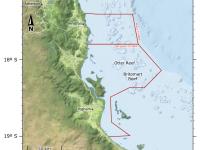
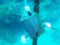
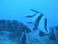
A baseline survey of green (no-take) zoned sites and blue (open to fishing) sites in adjacent areas of the northern Great Barrier Reef Marine Park was carried out in December 2006. Three paired sites were surveyed in the Cairns region on deepwater shoals in the vicinity of Green Island and Michaelmas Reef (one green, one blue site off each), and Hastings (Green) and Oyster (blue) Reefs. Assessment of the fish communities was enumerated using baited underwater video sets (BRUVS) and habitat was characterised by towed video.
Abundance and size of the sponge Coscinoderma matthewsi was surveyed at 5 island groups in November 2006: Ugar (Stephen Island) and Erub (Darnley Island) in eastern Torres Strait; and Masig (Yorke Island), Poruma (Coconut Island) and Warraber (Sue Island) in central Torres Strait. These island groups are on average, 66 km apart.Surveys were carried out at 7 or 8 randomly selected locations in each island group with each location at least 2 km apart, averaging 8 km. Each location was divided into 2 sites, approximately 200 m apart.
This experimental study of larval settlement behaviour of Coscinoderma mathewsi, undertaken in December 2009, explored some specific aspects of recruitment behaviour raised from the Torres Strait recuritment study.Research was conducted in tanks at Orpheus Island under controlled conditions to complement field recruitment studies in the Torres Strait (see separate metadata record).
In March 2007, November 2007 and May 2008, between 6 and 11 sites were surveyed on the coral reefs at Keats Island and Yorke Islands (Masig Island and Kodall Island), in central Torres Strait, to determine the abundance and size frequency patterns of Coscinoderma matthewsi. Sites were located at least 1 km apart and at each site, surveys were conducted at both shallow (4-6 m) and deep (10-12 m) depths, with the former generally on the reef flat. Three 20 x 1 m transects were examined at each depth, with transects separated by at least 20 m to retain independence.
During August 2005, sediment was collected from four reefs in the Whitsunday Islands and two adjacent midshelf reefs, situated along a previously studied water quality gradient. The reefs at Repulse and Lindeman Islands are influenced by discharge generated by the Proserpine and O'Connell Rivers. In the outer Whitsunday Islands, Hook and Edward Islands reefs, are subject to terrestrial influence, which is largely derived from the islands themselves. The midshelf reefs, Barb Reef and Reef 19-138 are essentially unaffected by terrestrial discharge.
A study of recruitment of marine invertebrates around Masig Island and Marsden Island, in central Torres Strait commenced in November 2006 and ended in November 2008.Terracotta settlement plates (11 cm x 11 cm) with well pitted surfaces were deployed at three locations on the northern side of each island, with locations two hundred metres apart. Each location was further divided into three sites, each twenty metres apart. At each site, five plates were deployed, roughly one metre apart, at both six metres and twelve metres depth.
A one-off study of the effects of handling on Coscinoderma mathewsi around Masig (Yorke) and Kodall (off Masig) Islands. Experimental work was carried out in 2009.Measurements of growth (cm) and survival were made to determine how handling might affect sponge growth and survival under aquaculture conditions.
To determine how handling under aquaculture condiditons might affect sponge growth and survival in Coscinoderma mathewsi.
Traditional use activities in the Great Barrier Reef Marine Park are managed under the Great Barrier Reef Marine Park Act 1975, and the Great Barrier Reef Marine Park Regulations 2019. The Great Barrier Reef Marine Park Zoning Plan 2003 recognises that under section 211 of the Native Title Act 1993, native title holders may undertake traditional use of marine resources in the Great Barrier Reef Marine Park.
Geoscience Australia has the primary role in the delineation of Australia's maritime boundaries. An output of this activity is the development of the Australian Maritime Boundaries (AMB) data. AMB is a GIS data product, replacing AMBIS 2001 Version 1.1, providing access to the data for Australia's Territorial Sea Baseline (TSB) and maritime zones.