Recent datasets

Published on 10 March 2021

This data set contains high frequency logging data to measure water depth, water temperature and electrical conductivity in project wetland sites. In addition fish catch data in wetlands recorded during this project, using electro-fish boat.

Published on 10 March 2021

The dataset consists of tables of means, with statistical differences indicated where they are significant, for measured crop performance, fertilizer N recovery and use efficiency at 6 field sites from Mackay to Freshwater. Runoff losses of N are also shown from sites at Freshwater and Silkwood.

**This dataset is currently under embargo until December 2021.

Published on 10 March 2021

This dataset contains the results of the water quality monitoring program conducted across the Russell-Mulgrave catchment (south of Cairns) for "Project 25". Project 25 spanned two (2) NESP TWQ projects: 2.1.7 (2016 - 2018) and 4.8 (2019 - 2020), with the dataset for Project 4.8 also containing the data for Project 2.1.7. Data is the result of discrete ‘grab’ samples analysed at TropWATER JCU laboratory for nutrients and sediments.

Published on 10 March 2021

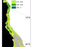
This dataset contains maps of alluvial and hillslope gullies across four large blocks of lidar covering portions of the Burdekin, Fitzroy, and Normanby Catchments. The gully polygons were generated using methods developed in the NESP 5.10 project for the extraction of gullies from lidar. Lidar is detailed topographic data collected from aircraft using an airborne laser scanning system.

Published on 9 March 2021

The dataset represents the code base developed for the generation of water quality metrics from various data sources (eReefs Biogeochemical models, MODIS Satellite imaging and AIMS in situ sampling).

Published on 9 March 2021

This metadata is a brief overview of the National Environmental Science Program Tropical Water Quality (NESP TWQ) Hub.
The aim of the National Environmental Science Programme (NESP) is to assist decision-makers to understand, manage and conserve Australia’s environment by funding world-class biodiversity and climate science.
The National Environmental Science Programme is delivered through six research hubs:
* Clean Air and Urban Landscapes Hub,
* Earth Systems and Climate Change Hub,
* Marine Biodiversity Hub,

Published on 25 February 2021

Geoscience Australias GEOMACS model was used to produce hindcast hourly time series of continental shelf (~20 to 300 m depth) bed shear stress (unit of measure: Pascal, Pa) on a 0.1 degree grid covering the period March 1997 to February 2008 (inclusive). The hindcast data represents the combined contribution to the bed shear stress by waves, tides, wind and density-driven circulation. The trimmed mean is simply the arithmetic mean calculated excluding a percentage of the highest and lowest values in the distribution.

Published on 15 February 2021

This dataset contains hillshading derived from the Digitial Elevation Model (DEM) dataset: Australian bathymetry and topography grid, June 2009 version 4 by Geoscience Australia. This dataset also contains the original DEM converted to a GeoTiff.

The hillshading was produced using the gdaldem tool.

The rest of this documentation is based on the metadata of the Australian bathymetry and topography grid itself. This grid is available from GA at http://dx.doi.org/10.4225/25/53D99B6581B9A .

Published on 8 February 2021

This dataset presents the raw data obtained from 1415 online and representative Australian that were asked to aesthetically rate 180 photos of typical coral reef landscapes. Mean aesthetic ratings of 180 photos were collected from the survey, as well as from an expert research team, contributing mean ratings of coral reef health, coral cover, coral pattern, coral topography, fish abundance, and visibility.

Published on 7 February 2021

This project integrated all the available source bathymetry data currently used within the latest gbr100 grid and generated a much higher-resolution gbr30 bathymetry grid (~30 m pixel spacing) over the GBR shelf area. The gbr30 grid is recommended for use as a spatial dataset to feed into the Local and Regional Decision Support Tool (DST) being developed by CSIRO for Integrated Pest Management.

Published on 4 February 2021

This dataset presents two excel spreadsheets containing the transect-based estimates of biomass carbon and condition score of study sites.

Published on 28 January 2021

Stereo-Baited Remote Underwater Video Stations (BRUVS) were deployed and retrieved in targeted shallow seabed environments within the proposed Oceanic Shoals Commonwealth Marine Reserve (CMR) in the Timor Sea. The survey concentrated on shelf habitats (< 200m) of the western part of the Oceanic Shoals CMR and included potential biodiversity hotspots such as pinnacles, banks and shoals. In total, 56 stereo-BRUVS were deployed between 31 and 77 metres for one hour according to a regular random sampling design, with minimum spacing of 400 m to ensure independence among samples.

Published on 25 January 2021

This polygon layer is a 'lite' version of the Digital Cadastral Database (DCDB) showing minimal attribute data about the property boundaries e.g.: base lot polygons, Lot and Plan attributes and an accuracy statement covering the whole of Queensland. See additional information also.

This data is updated nightly on the QSpatial portal, but only infrequently on the eAtlas. The versions setup on the eAtlas are retained for historic purposes.

Published on 22 January 2021

Surveys to determine abundance patterns of jellyfishes across the continental shelf were undertaken over three summers starting in December 2007 along three cross shelf transects (Cooktown, Cairns and the Palm Island Group).

Sampling was done in three strata at inner, mid and outer-shelf reef or island sites and an inshore beam-trawl survey. Within each distance strata sampling was done at two sites separated by 0.7 to 3 km and at each site two replicate one hour samples were taken for abundance data.

Published on 22 January 2021

The dataset depicts the proclamations made under the Seas and Submerged Lands Act (SSLA) 1973. This includes the continental shelf, the Exclusive Economic Zone (EEZ), territorial sea and territorial sea baselines.

Published on 22 January 2021

This dataset shows the effects of herbicides (detected in the Great Barrier Reef catchments) on the growth rates (from stem length and biomass) on the stonewort Ceratophyllum demersum during laboratory experiments conducted in 2019.

Published on 22 January 2021

This dataset shows the effects of herbicides (detected in the Great Barrier Reef catchments) on the growth rates (from cell density data) and photosynthesis (effective quantum yield) on the microalgae Chlorella sp. during laboratory experiments conducted from 2017-2019.

Published on 21 January 2021

P2R.data.reader.v041220 with Header.R

This is a block of R code written for NESP Tropical Water Quality Hub Project 3.1.6
The software uses data supplied from the Queensland Government’s Paddock to Reef (P2R) modelling system, and other publicly available data, to generate plots of supply curves for water quality credits in dissolved inorganic nitrogen (DIN) for the main catchments in the Wet Tropics.

Published on 21 January 2021

This dataset consists of monitoring data from macroalgae removal and larval seeding experiments in Florence and Arthur Bay at Magnetic Island, Queensland, Australia, collected between 2018-2020. There were twelve 5x5m permanent plots in each bay; three with macroalgae removal only, three with larval seeding only, three with macroalgae removal and larval seeding and three control plots. These data include:
- Stationary point count fish survey data
- Photo quadrats
- Coral recruitment to settlement tiles

Published on 18 January 2021

This dataset consists of one spreadsheet, which shows the survival, number of polyps and ability to remove sediment of up to fourteen weeks old Acropora millepora coral recruits while being exposed to three different climate scenarios resembling current climate conditions and conditions expected by mid and end of the century. Coral recruit resilience towards sedimentation was tested by exposing the recruits either five- and ten-weeks following settlement (experiment 1) or only ten-weeks following settlement (experiment 2).

Pages